

I've done the trip to Rotto from Freo a hundred times and because I'm good with a map and can see the island I haven't worried about a GPS. I've now moved up near Hillary's though and will be leaving from there. I know there's an outer reef you need to be careful of and years ago I did the trip with a mate and I think we lined up Observation City and Rotto to find the break in the reef. Any advice would be great.
More importantly, where is this reef and does it break ..... even better a lefthander....

Follow the ferry, thats what we did the first time we did it from there. Once you get past the marker out the front of Obs City its all gravy from there.
on the way back you can line yourself with the pine trees at North beach that will get you pretty much straight to the marker buoy turn left there and straight to Hillarys.
Get the compass bearings from the marker the next time you cross on a clear day as sometime Rotto is hidden by mist.
We ended up way south once before Rotto came into view couldn't believe how far of course we were.
Better still buy a gps if you can afford to run a boat you can afford a cheap gps it could save your life one day
Get a chartplotter , there are numerous types and price ranges to choose from ,The best electrical investment for your boat.
You can get them with all australian coastlines built in .
Makes night time travel on water much safer too.
Lots of built in features to make a day on the water alot safer
go to night school and learn to navigate . skills like filling the petrol tank 101 and reversing on boat ramps101 often dont cut it when there is the odd reef around
I have done the trip heaps both at day and night time, however can't remember the compass bearings now. You should at least get a compass and note the bearings on a clear day because mist or rain can come over very quick and you can lose your direction very quickly, and should learn some basic navigational skills so that you can tell what the basic Nav marks are saying.
However if you are heading over from Hillarys just head South inside the reef until you are clear of the safe water South cardinal marker (two triangles pointing down) that is off triggs/scarborough and then you can head for the Island and there is nothing in the way until you are nearly at the Island. Be careful though you will pass a marker first that is a safe water East cardinal marker that has two triangles pointing away from each other and so naturally you have to stay on the East (coast side of this).
When coming back, as someone said, you can head for the pine trees of North Beach (think it is James Steet) until you see the marker and go around the marker on the South side, sometimes you can't see these from the island so you head for Ob city first until you can see them or the marker.
Have you got your recreational skippers ticket? you learn how to read the Nav markers when you do it and it is not that hard, if you want to cruise the bays over at the Island you really need to know what the markers are telling you, it's really not that difficult and may save your life. As a volunteer Skipper for the Freo Sea Rescue vessel based on the island I pulled heaps of boats of reefs that wouldn't have ended up there if they knew basic navigation.
Cardinal Markers are on page 7-9 below however the whole lot is useful. http://www.seaschool.com.au/Boat%20Tips%209%20-%20Channel%20Markers,%20Buoys%20%20-%20Sea%20School%20240104.pdf
Rotto....rotto....rotto, did it once,, bit choppy on a surf cat.
ended up heading to big shape on horizon....US Enterprise, they
kindly pointed out my navigational mistake, blotto....blotto....blotto
Still got them all too BTW
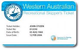
you get a plastic card for your R.S.T. in W.A. i keep the handbook handy just to brouse through and self assess.
Well, my Queensland one was printed on my Queensland drivers licence. Does this mean that QLD is more efficient and organised than WA?
interstate ticket valid for 3 months,
if you hold a current interstate skippers ticket and you enter western australia as a visitor with the intention of permanently residing in the state, it will be taken that you hold a recreational skippers ticket until 3 months have elapsed since you entered the state.
After that period you must apply for an RST, under the Skills Recognition scheme, if you wish to continue operating a RST vessel in this state.....
might be worth checking this out?
so no Qld is still less efficient
Arincini,
The chart app on the iPhone is Navionics Marine Australia, really good great backup for the chartplotter.
I am amazed at what they can fit into the iPhone. Want to know how windy it is, can even get a Wind Meter app. don't know how accurate.
Greenpat,
Easier way to remember the east and west cardinal is to remeber that west coast girls come in at the waist and east coast girls go out at the waist. (Hope nobody takes offence, none is intended.)
Ian