Can anyone advise which Gps/Map units they have found to be reliable I have a small H20 lorance and wish to upgrade. Advice please.
I use nearly 3 years Garmin 550 color witch ECHO and all AUS & NZ charts build in.
Recently tested 7 inch Lowrance, tons of features but,
I am till happy with mine, solid reliable unit.
iPhone No joke check out navionics on someone's iPhone $14.95 and as good as any chart plotter ( that's if yor eyes are ok otherwise get an iPad) stick it in a waterproof cover and you are set
Fraction of the price ( if you need a phone anyway) and you can check sea breeze for the weather too![]()
Agent, they great,but my understanding is
you pay for excess to charts.
You need ethernet connection and charts are downloaded as need it
Charts are not on your ipod.
Are charts for iPad available?
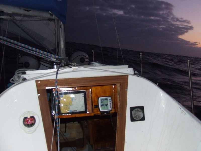
I've played with the Navionics on my iPhone and while it is great it doesn't have the features of my Garmin 276C chart plotter. My recommendation is use a laptop so you can see grib files etc. The Garmin 276C is integrated in to the tiller pilot, instruments etc and can also be mounted on the coach house running on its batteries so that I can navigate directly off the chart.
While I now use the plotter as my primary nav I always have the chart as a backup.
I downloaded Navioncs for Android onto my HTC Desire ($13.70 one off charge) and have never looked back. Used it to get from Mooloolaba to Lady Musgrave and back in my 37ft cat (including the great Sandy Straits at night) and never missed a beat. I used paper charts to check position all the time, but if Navionics said there was a beacon coming up, you better believe there's a beacon coming up. Never let me down. And no, there's no data charge as it just runs off GPS (I used it a long way out of phone range so I can vouch for that) and the updates are free. It's VERY good.
Petey
Great update, thanks guys,
I have HTC Desire but didn't bother, just too small.
I like Micheal's IPad, 10" would be just right for me.
You certainly swear by Seaclear Ramona.
I did download and install it on my PC and found the interface user friendly. Certainly more so than C-Map4.
As I understand it Seaclear only works with raster charts (scanned paper charts) and not vector charts (digitally generated charts).
Is that the case?
It occurs to me that if one was setting up nav electronics for coastal work a base line would be a DSS capable VHF radio with an active GPS antenna so that Lat/Long readings can be taken off the radio display and plotted onto a paper chart and that this would kept as a stand alone system.
This I am sure could be done for well under $1,000. Maybe as little as $500.
Then the ships nav capabilities could be enhanced with computer based chart plotting (very economical) or a dedicated chart plotter costing whatever you are willing to pay.
The DSS VHF with GPS antenna has got to be the way to go. I think it is now possible to buy such a radio with an integrated GPS receiver.
Graham,
The chart versus GPS accuracy problem is that the chart is to a different datum, or projection, than the WGS84 datum that GPS uses. A number of earlier charts have this problem which is often only a few metres but has been known to be measured in miles. I believe that Middleton or Elizabeth Reef north of Lord Howe is a few miles out on some charts compared to the actual GPS lat long.
It is a real issue so should be checked when using charts you are not familiar with.
Many charts have a fix marked to check GPS positions against the chart, the chart with Pittwater on it I believe is one of them, I don't have it here to check.
Cheers
John
I tried the Seaclear option before I got the iPad. The issue I had was that I didn't want to buy the laptop as a dedicated navigation device, and the difficulty I found in getting good maps that were useful 'to me' was proving almost as costly and time consuming as buying a Garmin or some such chart plotter. Once I did get it set up with the local Sydney maps, I took the laptop out on the boat and it lasted exactly one trip before it black screened (it was a write off from my company, an old IBM T42, so not surprising). Because I use the iPad for a lot of other stuff, it made sense to give the Navionics a go.
The accuracy of the Navionics on the iPad is very good, considering what it is. I know the co-ordinates of my mooring, and it's within a few metres depending on wind and swing, so it's good enough for me, for the kind of sailing I do. When passing through the Swansea Channel and bridge I watched the Navionics plotter and when I went throught the bridge, that's where it showed I was. Similarly with the channels and markers.
I also have a DSC VHF radio, a Midland Neptune 100 DSC, but I haven't plugged in the GPS Puck. I think I can use the one I got for the laptop, I just haven't got around to doing it.
Michael
The Navionics plotter charts will be the same WGS84 datum as other GPS plotters.
It is paper charts that are the problem. The best thing to do is check the chart datum and projection and allow for it. Most of the errors are minimal but there are the occasional one that can be of significance. Here are some links on the subject.http://www.amsa.gov.au/Shipping_Safety/Navigation_Safety/Positions_and_horizontal_datums_on_paper_and_electronic_charts/
www.gmat.unsw.edu.au/snap/gps/clynch_pdfs/Datum_i.pdf
The first link notes an error of 1 cable (200 yds) on Hornby Light at South Head. That is significant. In the fog last November we only had a couple of hundred yards vis.
All GPS nav needs to be backed up. At sea I use the paper chart, in pilotage or coastal situations I use visual. If the nav beacons/lights don't match up to what the chartplotter says I have a problem.
The December issue of Yachting World has an excellent article on the new Ipad and Navionics charts. Well balanced and shows the advantages and the disadvantages of these units. Also some examples of the programmes available.
The article is not on their webpage yet but I guess it will be sometime in the next 6 months.
marinedirectory.ybw.com/close/
The magazine also has several articles on large cruising catamarans which would be of interest to some here
An interesting dicussion.
The problem is mainly with older charts but has anybody noticed when your chart plotter switches between charts, either to cover another area or changing scale, the two charts don't line up i.e. the shore line has a kink in it. It appears not all charts in a chart plotter are necessarily to the same datum.
I did the RYA Yachtmaster Offshore theory course before Christmas and one of the good learning points was the use of GPS. I spent many years navigating aircraft in the Navy and have my seamanship ocean nav and pilotage tickets. I consider I'm reasonably OK at navigation (I've made many of the mistakes already). I got good value on how misuse of GPS/chartplotters leads to poor navigation.
Misunderstanding chart datums is one area, only sometimes significant, and another is misuse of chart plotters by not understanding actual track over the ground. GPS tells you where you are, not whether you should be there and what dangers being there and getting to your destination might present.
I discussed this with other yachties while on a cruise ship between Darwin and Torres Strait and down inside the reef. That is one area where poor use of chartplotters and lax navigation would present a very high risk. Currents are strong, channels not always wide and visibility in rain can be very limited.
To answer the original question by whiteout as to which GPS/map units are reliable, from my experience they are pretty much the same for accuracy and reliability. There are a lot of different solutions that work.
The way skippers use them is more likely to be the area of high risk.
This is stolen from another forum but is important to pass on because of the discussion concerning raster and vector charts and the increase in the use of vector charts as primary navigation aids. Just be aware of the problems associated with vector charts!
quote;
"Tend to agree with you about Raster/Vector charts.. if anyone is interested in the differences and limitations have a look here:
"At the UK Hydrographic Office, and many other national Hydrographic Offices, vector data (ENC) is created by tracing over the raster data. The significance of this cannot be overstated . The best quality image possible from this data can only ever approach the original raster image. When the electronic navigation chart (ENC) is displayed, with all possible display options enabled, the total amount of display information will still only approximate to that available from the raster image."
end quote.
This is from the manufacturer and supplier Visitmyharbour.
The linkhttp://www.chersoft.co.uk/nav_chartformats.htm
From a white paper by CherSoft, the company who produce "Easy Tide" for the UKHO.
Well thankyou for the great wealth of info on chart plotters I think I will continue on the search for a better plotter. Paper charts will continue my main reference with a new chart plotter search continues. Price and screen size are my main factors of influence. My ST40 Auto pilot continues to be used with alot of hand steering and local knowledge on reefs.
Some great information coming out in this thread.
A relevant question is:- Are records of GPS navigation now acceptable evidence in a Marine Incident Enquiry??