What do you think folks, was the breeze around Perth today a legitimate seabreeze?
Looked like one to me ![]()
Bit weak, but encouraging
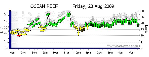
Looking at the graphs though, it was stronger on Melville water than on the coast.
That couldn't be a seabreeze, but where did it come from?
No, chart was all wrong it was just a gradient wind as the high was coming in and a forthcoming front is giving a bit of a push to the SSW'erly
That was the doctor coming a knockin' alright - three days running!
Sometimes it is stronger on Melville Water for whatever reason, and today was one of those days.
Thats not a seabreeze. Just because its wind from the south doesnt mean its a seabreeze.
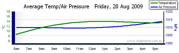
First of all it was onshore all day and secondly I dont think the temperature was high enough.
You need highs and lows with 'U' shaped isobars down the coast.
Am I right? This is what I thought anyway![]()
www.seabreeze.com.au/info/wind.asp
en.wikipedia.org/wiki/Sea_breeze
You are a day late Greeny. This was posted yesterday when the wind had changed from offshore to on shore.
Yes cos it was a gradient wind... the high rotates anti clockwise and the wind was initially SE and went S-SW in the arvo. Only cos of where the isobars were pointing.
It was not a seabreeze which is primarily caused by the thermal difference between land and sea ... and boosted a bit by the high coming in from the west
No way it was a seabreeze, sea surface temperatures are 17/18 degrees and the peak land temperatures would be lucky to be 2 degrees more than that the past few days.