Hi Guys/Gals
For all those strapped to a desk in Brisbane or Just north of Brisbane
GO HOME NOW
Gympie rd going under
Southpine rd under-Word of mouth
Pine river bridges down to 1 and talk of shutting the other
Evacuations for:
Caboolture
Strathpine
Goodna
Ipswich
I just drove back from city to northside, very bad- heaps of traffic even I will be trapped at home soon.
Drive safe everyone family before work.....
Heard from the Ex that she just made it to the airport with the kids before the bridge near where her Mum lives went under ![]() .
.
Her Mum is now stuck and reckons she won't be able to get back home for 3 days.
Good luck every one.
My 16yo neice was flying out today to Brisbane & bussing to Maroochydore for 2 weeks hols with some friends. My brother decided at the last minute to not let her go, after getting a phone call from the bus co. telling him that they would have to hole-up in a Brissy motel for the night due to road closure...she's shattered & very pissed at her dad, but I reckon her dad did the right thing?!
I hope all you guys and your families/friends stay safe up there, we're all thinking of you.
Wivenhoe is full and copped over 300mm since 9am this morning. It is all coming down the river and nothing is being held back any more. It won't peak until Thursday though.
This is actually a bigger event than 74. Ipswich will flood worse, Brisbane is predicted to hit 4.2m, possibly more 74 was 5.54.
Wivenhoe was built in the 80's to reduce flooding in BNE by 2m. Without it we would be staring at a flood well over 6m.
Holy shee-art!!
I must admit I have sorta been living under a bridge and not following this closely. ![]()
I don't get overly involved etc when the media arc up at the slightest sign of something to actually report but this is one kn mofo disaster awright.![]()
Best of luck to all affected.![]()
latest is that this will now be bigger than 74. 5.5m predicted in BNE on Thursday. I suspect it will be upgraded again in due course....
what i cant understand is how they couldnt predict the storm that caused the inland tsunami? or atleast pre warn people? and how they can justify global warming when they cant even get the next two days right?
![]()
![]() Bloody hell, we just turned TV on, what a disaster. Hope all you guys are safe up there in Queensland. Hope all are safe.
Bloody hell, we just turned TV on, what a disaster. Hope all you guys are safe up there in Queensland. Hope all are safe.
Mineral
Wow,we have been watching the devastation for a week now from up north and yesterday it moved west of Brisbane unbelievable .
We live on the Gold Coast and we have had enough rain to last a lifetime in the past few months BUT what's happening now and worse to come Thursday,this is a massive disaster in the making.
Good luck
To be honest the worst has probably been seen, from one perspective anyway. Flash flooding is what has taken the lives. probably up to 30.
Ipswich and Brisbane have plenty of warning. What you will see now is massive property damage....the flood is now predictable.
Man what a mess it is going to leave. My Brothers Pub is in South Brisbane and water went to the ground floor roof in 74. No chance of getting flood damage insurance so has to rectify it all himself....
It is turning out that owning a home on the river at Bulimba is not all that great, especially when the river is planning on visiting inside...
Note to self, don't listen to the missus, especially when looking for a home she says "Its on the river but, the dam will hold any flooding back!"..
Pontoon is gone, tied up to it was my new jetski, it crashed into the neighbours pontoon ripping it off, which ploughed into others and is gone somewhere..
The river is flowing so fast, never seen it like this before, cant imagine what the poor people in the lockyer valley have gone through.
Good luck to all in Brissy tonight and tomorrow...
Richo
Did you see the pontoon with bowrider ,jet ski and tinnie floating down the river,fk I love my boat and it was hard to watch.
Good luck my Brisbane/Queenslander brothers
we ought to take snapshots of the synoptic charts from the last month or so. some amazing shapes and lines all over the place
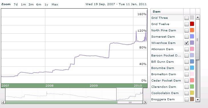
Some background....
There is a massive dam called Wivenhoe a few kms west of Brisbane - 2 purposes.
1) As a water supply for Main population zones in SE. All the figures for how full it is are rated against the water supply level.
2) As a flood mitigator - Wivenhoe's true capacity is (I think) 220% of 1) so over twice the capacity.
Within very recent memory it was around and under 20% so any inflows were gold.
That mentality is the reason that the capacity has been held at 100% or as near as for some months now. But have a look at the following charts and that is why point 2) above has had to be abandoned - dam failure would be equivalent to removing buildings / life for 3 + kilometres either side of the river all the way to the sea - = Ipswich & Brisbane and a myriad of smaller places - gone.
3 year profile
3 month profile
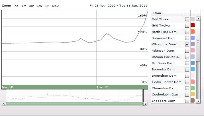
BTW it has been raining way above average since late November and the dam has been spilling to some degree since early December.
Safe fortunes to anyone in the path.
AP
These are not just "Brisbane Floods".
Major flooding has affected Rockhampton, Bundaberg, Maryborough,
Gympie, Toowoomba (really bad there), Laidley, Gatton, Grantham, Minden,
Boonah and many other small towns.
The aforementioned towns are on the eastern side of the water shed
where the run off is rapid to the sea.
Many towns and farming communities on the western side of the water
shed have had drastic flooding too.
Much of that water will flow down via the "Channel Country" and Cooper's
Creek into the Murray/Darling system. This should be called the
Darling/Murray system as the Darling River has the larger catchment area I
believe.
According to Sandra Sultry ![]() on 10 News, this scenario is shaping up to
on 10 News, this scenario is shaping up to
be the worst flood disaster in the whole of Australia's history.
My heart felt prayers go out to victims of the floods. I may be one myself as
my dream yacht was sitting in a cradle in the Maryborough Slipway yard
which I know has been flooded.
All of the flooding has been characterised by "suddeness". They have all
just happened so quickly that many were caught unawares.
This type of weather is something we on the east coast may have to get
used to annually.
A study was conducted some 10 odd years ago, by one of the government
agencies, of core samples taken from the coral reefs directly offshore from
the Burdiken River which has the largest catchment area of any of the east
coast rivers.
The growth rate of coral is known and the core samples represented 135
years of coral history which contained different levels of brown silt deposits
which represented annual rainfalls in that catchment area.
The official rainfall records only extended to 75 years prior to the study.
By comparing the official records to the natural records on a linear scale
the students/studiusts were able to determine that the silt deposit records
on the core sample were quite accurate.
The effect of this was that the people studying weather patterns were
able to extend their observations by another 50 years.
Their conclusions at that time were that Australia was overdue for about a
100 year cycle of very wet weather and that at the time of Cook's mapping
of the east coast of Australia the country was at the end of such a cycle
thereby causing him to report back to his royal masters that the country
looked "very fair". Upon this description of the country the royals decided
to colonise the place.
So it seems that describing Australia as "The Dry Country" is a misnomer.
The study I have described above was aired on national television.
I know because I watched it.
I doubt you will be able to confirm what I have related because the
"Global Warmists", the "Red Ranga Welsh Bitch", Wong, Garrett, Combet
and the rest of them do not want you to know about this.
It is just the same as the "Sustainable Housing Study" conducted by the CSIRO 30 odd years ago that I have previously mentioned on this forum.
You can't find the information.
You 30 somethings who are supposedly the next generation of leaders in this country need to realise you have been treated like mushrooms at school. Fed on bulldust and kept in the dark.
I am willing to bet $100 that within the next 12 months some lame duck politician, beaurocrat, pollie paid professor or greenie blames the floods on "Global Warming".
Anybody want to take the bet???
Just an aside.
The Wivenhoe Dam is only an earth and rock wall dam for the main part.
If it goes, kiss Brisbane good bye.
Which surrounding suburbs of brisbane need to be ready to get on the roof. I realize flash floods are hard to predict coz it's harder to pick where a tributary may burst it's banks. I am particularly interested in coomera waters....
i don't think you need to worry wotzy,
coomera river is a completely different system to the brisbane river and catchments.
i had a look on the bom site and there are no real flood warning for the logan or alberts which are on the goldy near the coomera.
but check out the bom site.
Good luck to all in Brisbane and Queensland in general.
Prepare for worst. Hope for the best. Good luck.
Wyvenoe is a worry. Good luck to the dam engineers out there - they would be very very concerned at present.
Seabreeze is a great tool in events like this
A twitter site is also qldfloods.org/
Alternate flood mp site http://lexiphanic.com/floodmaps/
Strongest La Nina www.abc.net.au/unleashed/42858.html
I have a lot of mates up in the Brisbane floods - amazingly, they are in the evac suburbs, but all live on high hills - so are staying put stocked up with food. The reasons they gave me "just trying to keep it real" ![]()
They still have electricity and internet at the moment.
Work mates down here in VIC happy to contribute money to the relief fund, but a lot of comments going around about how the Gov and Contractors tend to p1ss these types of funds up against a wall when it comes to spending on recovery. I know an Engineer who won similar rebuild gov tenders and he seemed to support this way of thinking, that the companies do milk those opportunities...... not cool.
Wivenhoe has massive flood gates that can release any inflow the catchment can throw at it. From memory it can release the contents of Syd Harbour in a day. It is not in danger of failing and has been designed to handle much worse situations than this. The issue is that was almost full (max flood capacity) when this latest rain event hit. Accordingly it has no capacity to hold back any more to mitigate the flood and anything flowing into it is immediately released. The cup is full....and is now runneth over...
For those that are questioning the warning for the Toowoomba and Lockyer Valler flooding on Monday, you are not grasping the difficulties of doing this in the timeframe involved. This was something that happened very quickly - and I mean the actual formation of the rain cloud to the flood event. The supercell formed, dumped, flooded and dissapeared within 1 hour, not hours. Even if a forecaster could predict that a cell like that could have formed, they could never predict where it would hit and the impacts in the timeframe. Also once it started dumping if someone was lucky enough to have seen the magnitude, realised the risk, but then had no more than 15-30mins to warn people. You might have a chance of doing something minor in Toowoomba, but I doubt the outcome would have changed much. 5-10mins warning is all the local authorities might have had at best. However in Lockyer, which is 150ks from Brisbane you are talking about rural properties and a couple of local cops per 1000 square ks. You would struggle to warn everyone if you had a day let alone an hour.
Most of the lost lives were in that first hour or two on Monday. Since then the emergency responce has been very very good. Quite impressive actually.