What is happening with Bianca in WA? (currently a TC 3)
Is Ex TC Anthony reforming towards NQ- some people predict it to hit NQ on the weekend. However, BOM is not giving away much forecast.
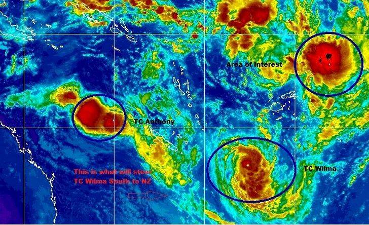
Tropical cyclone Wilma, currently a category 4 cyclone, is moving
westsouthwest where ever that can go toward.
Lets hope that the Coasts of Australia and the Islands in the oceans will be save and we only get great winds to kite out of this.
Thoughts?
Predictions?
These models are changing rapidly, and are only accurate to about 3 days out. There is a lot of worried people in Queensland ATM.
Another possible model here...
wxweb.meteostar.com/models/ipsm_looper.php?PROD=2011012618_ANZ_GFS_SFC_WINDS_SLP
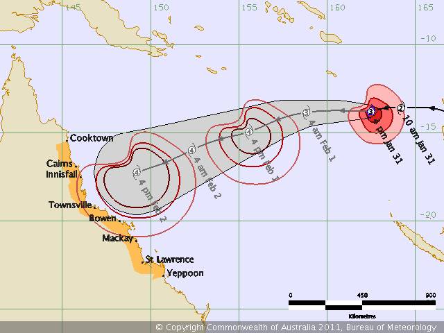
Ex TC Anthony is looking like re-intensifying and may cross near Townsville on Monday mourning as a Cat 2.
TC Wilma is supposed to start on its track SE to NZ soon, however the area to watch for the moment is NW of Fiji as a tropical disturbance develops there.
Yep still a long way out but that long range and the GFS long range have that cyclone hitting the east coast sat week .the GFS has it making landfall (deintensified but still a big storm by the look of it) hitting the hunter valley and mid north coast NSW
Latest GFS model looks better for SE/QLD but look out our brothers to the north!
wxweb.meteostar.com/models/ipsm_looper.php?PROD=2011012700_ANZ_GFS_SFC_WINDS_SLP
SOME MAD EYEWALL FOOTAGE FROM THE STATES![]()
I dont know of any Cyclones to hit NSW. Does anyone know of one. And i dont remember a Cyclone tracking from the south back up north. Weird weather were having.
Always a silver lining.. to every sheet of corrugated iron flying past eh Rellie? ![]()
depends on which model ya look at but some area suggesting it (anthony) is going to come into land just above Townsville Sun night and then followed up by another if it forms around about Thursday Friday next week .
Local swell should increase dramatically from Sat morning ![]()
In NSW we call them Low pressure systems and YES we have had plenty that are similar in strength to the "Cylcone". They pass between Australia and NZ regularly in the winter time
www.bom.gov.au/products/IDQ65002.shtml
its coming for us!
Hi Miko we are keen to catch up in next days in Alva
Looks like that bigun next thurs Fri is pretty certain .This morning GFS run has yet another smaller one 4 days later
first one just coming on the 250km radar of townsville.
2nd system is huge!~ lets hope it weakens
www.goes.noaa.gov/sohemi/sohemiloops/shirgmscol.html
This pic gives you an idea of how much bigger Yasi is compared to Anthony....she is now heading straight at Qld, may arrive around next Thurs / Fri.
TC Yasi expected to hit the coast late Wednesday night / early Thursday morning......possibly intensifying to a Category 4.
Batten down NQ, could be nasty!
Hey Marv, just interested to know if you guys are evacuating or if not what precautions/preparations you are undertaking, keep safe and all the best.
Top
Hope you have some high ground to wait this out, I would be making a run for it.
Cheers for the update link on WZ.
Hey Marv,
Bianca Cyclone when it went past Karratha was only Rain and a bit of wind looks like York copped a Flogging tho in Perth.
**** Mate if you best head over to K Town and we go fishing.
Yasi looks bad as wonder if it tracks straight across to us?
Good Luck Bro
We had a cat 5 in 99'. Good luck and don't be a hero trying to save your house.
Old fibro houses will not stop a star picket doing 250km. we had a star picket go through the wall and then through the back of the fridge right into the door.